|
|
| |
|
|
|
||||
|
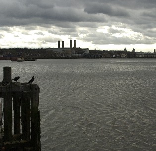
There is a big, publicly accessible jetty here. The views of the riverscape are fantastic, and there is a great deal of information about the industries and landmarks you can see on some metal plaques here, if you can see through the grafitti. By the 1980's the docks were almost derelict. There were many reasons
for the decline and they were the source of a lot of debate in the interviews
I listened to in the Museum in Docklands collection. Explaining the decline
of London Docks would have been the kind of topic that you could have
found in a dry old 'O' level geography paper. If I had tried to summarise
it myself in five minutes it would have probably sounded pretty dry. I
think that hearing the analysis of people who lived the history and lost
their jobs gives the different theories a certain power; I wanted to see
if memories could help explain quite complex economic history and geography. And the
view from here, of so much of the redeveloped docks in the Isle of Dogs, seemed like a great
place to put things into a bigger picture. |
| Home | FAQ | Links | Copyright | Download Audio Walk | Feedback | Ordering Walk CDs | Press |